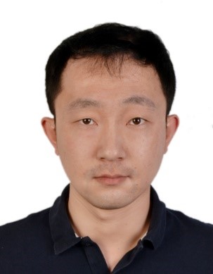
- 姓名: 李晓冬
- 性别: 男
- 职称: 研究员
- 职务:
- 学历: 博士研究生
- 电话:
- 传真:
- 电子邮件: lixiaodong@whigg.ac.cn
- 所属部门: 环境与灾害研究部
- 通讯地址: 湖北省武汉市武昌区小洪山西30号
1983年出生,博士,研究员,硕士生导师。入选湖北省省杰青、武汉青年科技晨光计划、中国科学院创新青年促进会,主持国家自然科学基金青年项目、面上项目。主要从事遥感影像时空分析、多源遥感数据融合、土地覆盖制图与变化检测研究。以第一作者在Remote Sens. Environ., IEEE Trans. Geosci. Remote Sens., ISPRS J. Photogramm. Remote Sens., IEEE J. Sel. Topics Appl. Earth Observ.等国际刊物上发表研究论文10余篇,以第一作者在Photogramm. Eng. Remote Sens.发表的论文Sub-pixel-scale Land Cover Map Updating by Integrating Change Detection and Sub-Pixel Mapping获得美国摄影测量与遥感学会Boeing最佳论文奖(Boeing Award for Best Scientific Paper in Image Analysis and Interpretation);2018年获英国国家学术院British Academy交流资助。
2002-2006年,中国地质大学(武汉) 地理信息系统专业 学士
2006-2009年,中国科学院测量与地球物理研究所 自然地理学专业 硕士
2009-2012年,中国科学院测量与地球物理研究所 自然地理学专业 博士
2012-2014年,中科院精密测量院(原中科院测地所) 助理研究员
2015年-2020年,中科院精密测量院(原中科院测地所) 副研究员
2020年-至今,中科院精密测量院(原中科院测地所) 研究员
2018,英国诺丁汉大学访问(British Academy资助)
简 历:
社会任职:
遥感影像时空分析;数据融合;超分辨率制图
研究方向:
湖北省杰出青年基金:基于多源遥感影像时空融合的快速城市化地区土地覆盖高分辨率动态监测(2018-01-01至2020-12-31);
自然科学基金面上项目:融合多时空尺度遥感影像的高时空分辨率地物制图(2016-10-01至2020-12-31);
中科院青年创新促进会(2017-01-01至2020-12-31)
承担科研项目情况:
1. Li Xiaodong, Giles M. Foody, Doreen S. Boyd, Ge Yong, Zhang Yihang, Du Yun, Ling Feng, SFSDAF: An enhanced FSDAF that incorporates sub-pixel class fraction change information for spatio-temporal image fusion, Remote Sensing of Environment 2020, 237 https://doi.org/10.1016/j.rse.2019.111537.
2. Li Xiaodong, Ling Feng, Giles M. Foody, Ge Yong, Zhang Yihang, Wang Lihui, Shi Lingfei, Li Xinyan, Du Yun. Spatial-temporal super-resolution land cover mapping with a local spatial-temporal dependence model, IEEE Transactions on Geoscience and Remote Sensing 2019, 57(7), 4951-4966.
3. Li Xiaodong, Ling Feng, Giles M. Foody, Ge Yong, Zhang Yihang, Du Yun, Generating a series of fine spatial and temporal resolution land cover maps by fusing coarse spatial resolution remotely sensed images and fine spatial resolution land cover maps, Remote Sensing of Environment 2017,196:293-311.
4. Li Xiaodong, Du Yun, Ling Feng. Sub-Pixel-scale land cover map updating by integrating change detection and sub-pixel mapping. Photogrammetric Engineering & Remote Sensing. 2015, 81(1): 59-67.
5. Li Xiaodong, Ling Feng, Du Yun, Feng Qi & Zhang Yihang. A spatial-temporal Hopfield neural network approach for super-resolution land cover mapping with multi-temporal different resolution remotely sensed images. ISPRS Journal of Photogrammetry and Remote Sensing, 2014, 93: 76-87.
代表论著:
专利申请:
美国摄影测量与遥感学会波音图像分析与解译最佳论文奖(第一作者);湖北省省杰青;中科院青促会会员。


人才队伍